
Southwest Monsoon Advances, ‘Super El Niño’ May Impact Rainfall in India
IMD Warns of Rising Heatwave Conditions in Odisha as El Niño Threatens Weak Monsoon Rainfall
The southwest monsoon has further advanced into several parts of the southeast Arabian Sea, southwest and southeast Bay of Bengal, most parts of the Andaman Sea, the entire Nicobar Islands, and some areas of the Andaman Islands including Sri Vijaya Puram. According to weather forecasts, the monsoon is likely to reach Kerala by May 26.
At the same time, weather experts have warned that a possible “Super El Niño” condition may become active by June or July, which could significantly affect India’s monsoon rainfall this year.
‘Super El Niño’ May Trigger Drought-Like Conditions
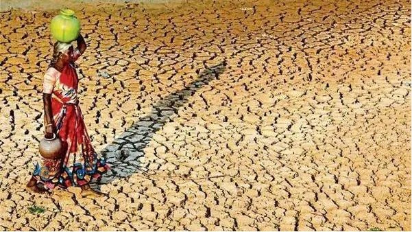
Meteorological analysts have cautioned that the development of El Niño conditions over the Pacific Ocean may reduce rainfall during the monsoon season in India. The four-month monsoon season contributes nearly 70 percent of the country’s annual rainfall and plays a crucial role in agriculture, crop production, water reservoirs, and the overall economy.
This year, India may receive below-normal rainfall, raising fears of drought-like conditions in several regions. The country is expected to receive around 80 cm of rainfall during the monsoon season, lower than the long-term seasonal average of 87 cm.
Rainfall Likely to Decline in August and September
According to weather analysis agencies, rainfall during June may remain near normal. However, a significant decline in rainfall is expected during August and September due to strengthening El Niño conditions.
The India Meteorological Department (IMD) had earlier indicated that neutral conditions over the equatorial Pacific Ocean are gradually shifting toward El Niño conditions, which generally lead to reduced rainfall across India.
Heatwave Conditions Intensify in Odisha
Meanwhile, heatwave conditions have intensified across Odisha, with temperatures likely to rise by another 2 to 3 degrees Celsius over the next two days, according to the Meteorological Department.
Hot and humid weather conditions have increased discomfort across the state. On Sunday, temperatures crossed 40 degrees Celsius at nine locations.
Hirakud recorded the highest temperature at 41.5°C, followed by Jharsuguda and Sambalpur at 41.4°C each. Bhawanipatna recorded 41°C, Angul 41.1°C, while Talcher, Titlagarh, Sonepur, and Nayagarh also witnessed temperatures above 40°C.
In coastal Odisha, temperatures hovered between 37°C and 38°C. Balasore recorded 38°C, Chandbali 38.8°C, and Bhubaneswar 37.8°C along with severe humidity and discomfort.
Thunderstorm Alert Issued for Odisha
A well-marked low-pressure area remains active over the southwest Bay of Bengal and adjoining west-central Bay of Bengal. However, weather officials said the system is not expected to have any major impact on Odisha.
Despite this, the state is likely to experience Kalbaisakhi (nor’wester) thunderstorms over the next five days. The Meteorological Department has issued a yellow warning for thunderstorms accompanied by lightning, rainfall, and gusty winds in several districts.
Officials said the gradual transition from neutral conditions to El Niño could eventually result in weaker monsoon rainfall during the season.
Comments are closed.